Written by the Maui Snorkeling team, operating Molokini Crater, Turtle Town, and Coral Gardens tours out of Maʻalaea Harbor since 1985. Tours are led by USCG‑licensed captains aboard a USCG‑inspected passenger vessel. We spend more days in these waters than on land.
Last updated: February 2026
Molokini Crater Hawaii is more than a famous snorkeling spot; it’s a protected place with a deep geological, cultural, and conservation story.
Formed by volcanic activity roughly 230,000 years ago, Molokini later became an important fishing and resource area for early Hawaiians, was impacted by WWII-era military use, and is now safeguarded through modern marine management.
This guide focuses on history + conservation: what Molokini is, what happened here, why it’s protected today, and what stewardship looks like going forward.
If you’re looking for snorkeling logistics, rules, or tour details, use these instead:
- Molokini Snorkeling Guide (planning)
- Molokini Crater Visitor Guide (rules + marine life)
- Molokini Crater Snorkeling Tour
Molokini Crater, Hawaii Timeline: Past, Protection, and Modern Management
Molokini Crater’s story is shaped by two big forces: how it formed and how it’s protected today. The timeline below highlights the turning points that transformed Molokini from a remote volcanic islet into one of Hawaiʻi’s most closely managed marine destinations.
Key Dates at a Glance
| Date | Milestone | Why it matters |
|---|---|---|
| ~230,000 years ago | Molokini forms from volcanic activity | Establishes Molokini’s origin as a volcanic cone/islet and sets the foundation for the underwater habitat we see today. (USGS) |
| 1977 | Molokini Shoal becomes a Marine Life Conservation District (MLCD) (HAR 13-31) | This designation creates the modern legal framework that protects Molokini’s marine life and guides how people can use the area. (Hawaii DLNR) |
| 1981 | Commercial operator permitting system begins | A management response to growing visitation—designed to limit and control commercial use at Molokini. |
| 1987 | Day‑use mooring buoys begin | A practical conservation step to reduce anchor damage and concentrate boat use in managed areas. |
| March 15, 2024 | Rule updates take effect (MLCD + day‑use mooring program) | DLNR updates and clarifies the rules that guide use, access, and resource protection at Molokini. (Hawaii DLNR) |
Note: This page is intentionally focused on history + conservation context. For a visitor-friendly summary of current do’s/don’ts, read our Molokini Crater Visitor Guide (Rules + Marine Life).
Why the 1977 MLCD Designation Changed Molokini’s Future
When Molokini Shoal was established as a Marine Life Conservation District (MLCD) in 1977, it marked the beginning of modern, place-based protection for the area under Hawaiʻi Administrative Rules (HAR 13-31). In plain terms, Molokini stopped being “just a scenic offshore islet” and became a legally protected marine area where conservation is the priority.
That protection became more important as Molokini’s popularity surged. The Conservation Action Plan for Molokini describes how increased visitation raised concerns about crowding and reef damage from boat anchors, prompting the state to adopt more structured management measures, such as commercial operator permits (1981) and day-use moorings (1987).
It also helps explain why Molokini is treated differently than many “normal” snorkel spots: it’s not only a recreation site; Molokini is also part of a broader protection story (including the fact that the islet itself is off-limits as a bird sanctuary).
What’s Changed in Recent Management
Molokini’s management hasn’t been frozen in time. DLNR updates rules periodically as conditions, visitation levels, and conservation needs evolve.
Most recently, DLNR’s Division of Aquatic Resources lists crucial amendments and additions affecting the Molokini MLCD and the day‑use mooring program, with updates spanning HAR Chapter 13-31 (Molokini MLCD), Chapter 13-230 (General Provisions), and Chapter 13-257 (Day‑Use Mooring Rules)—effective March 15, 2024.
At a high level, these modern updates reflect a consistent direction of travel in Molokini’s stewardship:
- Clearer management of boat use (especially around moorings)
- Reduced physical impacts to reef habitat (historically linked to anchoring pressure)
- More precise definitions (boundaries, use expectations, and administrative framework)
For the visitor-friendly breakdown of what those updates mean on the water, link here: Molokini Crater Visitor Guide (Rules + Marine Life). For the official rulemaking summaries, link to DLNR’s Rules and Public Notices page.

Photo courtesy of Wikipedia
Geological History of Molokini Crater: How the Tuff Cone Formed
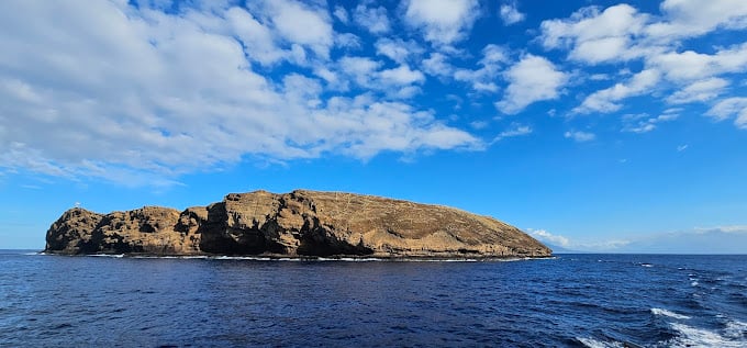
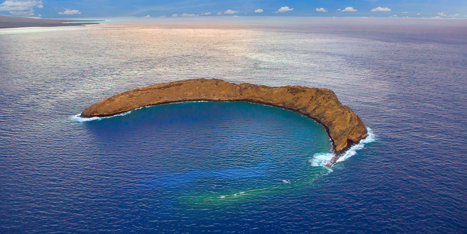
Molokini is a horseshoe-shaped tuff cone, a volcanic landform created by explosive eruptions where magma meets seawater. It’s part of the volcanic story of Haleakalā’s southwest rift zone, and its famous crescent shape is the result of erosion and partial submergence, not a “half-crater” eruption.
The crater covers ~22 acres. At its highest point, it rises about 161 feet above sea level. At its deepest, it dips down to about 300 feet below the water’s surface.
How Old is Molokini Crater?
According to the U.S. Geological Survey’s Hawaiian Volcano Observatory, Molokini erupted about 230,000 years ago.
USGS also describes Molokini as a volcanic cone that rises about 150 meters (500 feet) from the submarine flank of Haleakalā to a summit about 49 meters (162 feet) above sea level; one of the clearest “at a glance” ways to understand its overall scale.
What is a Phreatomagmatic Eruption?
A phreatomagmatic eruption involves both magma and water, which typically interact explosively, ejecting steam and volcanic fragments.
Molokini is a classic example of this kind of hydromagmatic activity. USGS notes that Molokini would resemble other cinder cones along the rift—except it erupted through water. In shallow seawater, liquid water heats rapidly, flashes to steam, and adds extra force, shattering lava into smaller fragments and helping build ash-rich deposits that can become tuff over time.
In short:
magma + shallow seawater → explosive fragmentation → ash/tephra builds the cone → deposits can cement/alter into tuff.
Molokini’s Size, Elevation, and Depth
Here are the most useful “geo quick facts” for understanding Molokini’s physical form:
| Quick fact | What it means for the geology |
|---|---|
| Type: Horseshoe-shaped tuff cone | A hydromagmatic cone made from explosive magma–water interaction. (Hawaii DLNR) |
| Area: ~22 acres | A small islet—its scale is “compact,” but the underwater structure is much larger. (Hawaii DLNR) |
| Top elevation: ~160–162 ft above sea level | The visible rim is relatively low, but the cone rises far more from the seafloor. (Hawaii DLNR) |
| Vertical relief: ~150 m (500 ft) from the submarine flank | This is the “true” volcano scale: most of Molokini’s structure is underwater. (USGS) |
| Underwater profile: slope to ~100 ft, then drop to >250 ft | The outer slopes get deep quickly—especially along the steeper side of the crater. |

Cultural History of Molokini: Ancient Hawaiian Fishing and Resource Use
Long before modern recreation brought large numbers of visitors offshore, Molokini was part of the living seascape of South Maui, a place tied to sustenance, navigation knowledge, and cultural practice. Research and cultural writing describe Molokini as a resource area where Kānaka Maoli (Native Hawaiians) fished and gathered materials from both the ocean and the islet’s seabird environment.
Molokini in the Honuaʻula District of South Maui
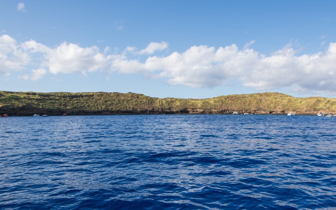
Molokini sits in the ʻAlalākeiki Channel, about three miles off Maui’s southwestern (South Maui) coast—the same coastline that includes places like Kīhei, Wailea, and Mākena.
In traditional terms, this is the coastal region associated with Honuaʻula. In one Ka Wai Ola feature describing Mākena’s fishing traditions, the article notes that Mākena is in the ahupuaʻa of Kaʻeʻo, within the moku of Honuaʻula, and emphasizes that this area’s strength as a fishing region included proximity to the “abundant resources” of nearby Molokini and Kahoʻolawe.
Archaeological Evidence (Stone sinkers and Lures)
There is physical evidence supporting the longstanding use of Molokini’s waters. A detailed report on marine recreation and management at Molokini notes that Native Hawaiians utilized Molokini as a source of fish, birds, feathers, and eggs, and that traditional fishing stone sinkers and lures can still be found in the waters surrounding the islet.
Cultural reporting also emphasizes that while there is no evidence of permanent residence, artifacts indicate kūpuna (ancestors) stopped at Molokini for fishing and for gathering materials such as plumage, bird eggs, limu, shellfish (clams/mussels), and ʻēkaha kū moana (black coral)—resources that were used for subsistence and cultural practice.
What this evidence suggests:
- Molokini functioned as a visited resource place—a destination for fishing and gathering rather than a settled community.
- The “tools” (sinkers/lures) point to repeated, practical use of the area’s marine productivity over time.
- The cultural importance extends beyond food: traditions, chants, and moʻolelo (stories) connect Molokini to broader Hawaiian understandings of place and genealogy.
Why There Were No Permanent Settlements on Molokini
Multiple sources emphasize a key point: there is no evidence that Kānaka Maoli lived permanently on Molokini. Instead, Molokini appears to have been used as a place where people fished, gathered seabird resources, and maintained cultural practices associated with the area.
Molokini’s cultural importance is also described in deeply place-based terms. Ka Wai Ola notes that in some moʻolelo, Molokini is regarded as an ʻīewe and piko (a spiritually significant center/connection point), and that some families would place the piko (umbilical cord) of their children at Molokini in hopes the child would grow into a skilled navigator and fisher.
A separate management-focused report describes related traditions of placing a newborn’s placenta in nearby waters (including the Kealaikahiki Channel area between Kahoʻolawe and Molokini) as part of a cultural practice tied to seafaring identity.
Molokini Hawaiian Mythology: Pele, Molokini, and Puʻu ʻŌlaʻi
Molokini is widely known today for its striking crescent shape, but in Hawaiian tradition, it’s also recognized as a wahi pana (storied place) with moʻolelo (traditional narratives) that connect the islet to the people, winds, and landscapes of South Maui. As with many Hawaiian stories, versions can vary by family and place, and the same landscape may hold multiple layers of meaning.
The Molokini Love-Triangle Legend (Pele and the Prince)
One of the best-known moʻolelo tied to Molokini is a love-triangle story involving Pele and a handsome aliʻi (chief, often translated as “prince” in modern retellings) named Lohiʻau.
In a South Maui/Honuaʻula telling documented by the Office of Hawaiian Affairs, a moʻo (water guardian being) named Inaina took the aliʻi Lohiʻau as her lover while he lived at Māʻalaea. When Pele learned of the relationship, she fought with Inaina in jealousy. In the story, Inaina’s body becomes the geography: her tail becomes Puʻu ʻŌlaʻi in Mākena, and her head becomes Molokini.
A closely related version shared in Ka Wai Ola (which cites Hawaiian scholar Abraham Fornander’s recordings) tells of a shapeshifting moʻo figure and again links the story to a moral lesson: Kamohoaliʻi (Pele’s elder brother in the telling) rebukes Pele’s rashness and a “kānāwai inaina” (a decree/law) is proclaimed encouraging kindness rather than cruelty—an ethical teaching anchored to the place itself.
Note: Ka Wai Ola also records another Pele-related creation moʻolelo where Molokini is described as a younger sister of Pele, and Pele’s jealousy transforms her into an islet—another reminder that Molokini’s “creation stories” exist in more than one form.
How Makena and Puʻu ʻŌlaʻi Connect to Molokini Stories
The reason these stories feel so “rooted” is that the key landmarks are visible and geographically connected.
Puʻu ʻŌlaʻi (often written Pu’u Ola’i) is a prominent cinder cone at Mākena State Park on the South Maui coast.
In the moʻolelo recorded by OHA and retold in Ka Wai Ola, Puʻu ʻŌlaʻi is not just a nearby hill—it is explicitly identified as one part of the same story that also forms Molokini.
This creates a powerful cultural geography: Mākena (land) and Molokini (sea) are linked through narrative, reinforcing how Hawaiian place-stories often weave together human relationships, spiritual lessons, and physical landmarks. In this case, the landscape becomes both a remembered event and a reminder of values—especially the story’s teaching about restraining jealousy and practicing kindness
Molokini in World War II: Military History and Legacy Impacts
Molokini’s modern conservation story can’t be separated from its WWII-era history. During World War II, the crater’s isolated location and distinctive outline led to military use that left lasting marks—both on the landscape and on how the public and agencies approached stewardship afterward.
Why Molokini was Used for WWII Target Practice
During WWII, the above-water portion of Molokini was used for bombing practice because its size and shape were deemed similar to those of an enemy warship, making it a convenient training target.
At the same time, Molokini’s navigation light—installed earlier as a safety feature—was extinguished during WWII for security and was ultimately destroyed by practice bombs during the period when Molokini was used for target practice.
What was Damaged
Molokini did not experience destruction on the scale of nearby Kahoʻolawe, but it was still impacted. Historical reporting on Molokini’s management context notes multiple legacy effects tied to the military period and its aftermath, including:
- Infrastructure loss: the navigation light was destroyed by practice bombing.
- Reef/habitat damage from post-war response: after military activities ended, the U.S. Navy detonated large unexploded bombs that remained inside the crater, and this event caused major coral reef damage that observers report can still be seen in the crater today.
How WWII Impacts Accelerated Conservation Awareness
WWII-era use didn’t just leave physical impacts—it also shaped public expectations about protection. In the historical record used for the modern management context, public outcry over how unexploded munitions were handled at Molokini is described as a key factor that pushed the Navy to remove most remaining WWII-era bombs from the crater.
That same stewardship-through-restraint shows up in more recent decisions. In 2020, Hawaiʻi DLNR publicly stated there were no plans to “detonate-in-place” two WWII-era munitions off Molokini, emphasizing a preference for solutions that avoid unnecessary damage to marine resources while still addressing safety concerns.

Photo Courtesy of MolokiniCrater.com
Conservation at Molokini: MLCD, Seabird Sanctuary, and Stewardship
Molokini is protected through layered stewardship—a combination of marine protections, wildlife sanctuary safeguards, and active management designed to reduce human impact while keeping the ecosystem resilient over time. At a high level, Molokini’s protection “stack” looks like this:
In the water: the Molokini Shoal Marine Life Conservation District (MLCD) (managed by DLNR’s Division of Aquatic Resources).
- On the islet: Molokini is part of the Maui Offshore Islet Seabird Sanctuaries, where visiting/landing is prohibited to protect nesting habitat and prevent the introduction of invasive species.
- For boating pressure: day‑use moorings + commercial operator management help minimize anchor damage and crowding.
- For accountability: ongoing research, monitoring, and data-driven management (DAR + University of Hawaiʻi partners).
1977 Molokini Shoal Marine Life Conservation District
Molokini Shoal is a Marine Life Conservation District (MLCD) established in 1977 under Hawaiʻi Administrative Rules (HAR) 13‑31 (often summarized by DLNR as “approx. 77 acres”).
The MLCD designation created a legal and management foundation that prioritizes marine resource protection—and it also changed what happened next. A NOAA-hosted Molokini Conservation Action Plan explains that as visitation grew after the MLCD designation, regular users raised concerns about overcrowding and potential reef damage from boat anchors.
In response, the state began building a more structured management system (including commercial operator permitting in 1981).
Seabird Sanctuary Protections
Molokini is also part of Hawaiʻi’s state Seabird Islet Sanctuaries, and DLNR’s wildlife program explicitly states that visiting Molokini is prohibited.
The reason is straightforward and strongly conservation-led: these offshore islets are rare nesting places where seabirds can raise young with fewer predators and without human trampling that can collapse burrows. DLNR also notes these sanctuaries reduce disturbance for resting turtles/seals and help prevent people from unintentionally introducing weed seeds and alien pests.
Moorings and Managed Visitation
As Molokini’s popularity increased, management shifted from “designation” to day-to-day impact control. The Conservation Action Plan describes how the state responded to early concerns by establishing commercial operator permitting (1981), and then installing the first Day‑use Mooring Buoys (DMBs) in 1987—a practical move to reduce anchor-related damage and concentrate boating activity into managed attachment points.
The plan also clarifies that the Day‑use Mooring Buoy system involves multiple agencies (including the state boating program’s jurisdiction over the mooring system), reflecting that Molokini’s stewardship isn’t “one rule,” but coordinated management across responsibilities.
As use scaled up, management evolved again. The plan notes that by 2009, DLNR/DAR revised elements of the commercial permitting approach to minimize recreation impacts and obtain better human-use data, including requiring operators to submit monthly use logs (including reporting activity and moorings used). That’s “modern Molokini management” in practice: measure use, manage pressure, and adjust.
Research and Monitoring
Molokini’s stewardship is increasingly science-led because you can’t manage what you don’t measure. The Conservation Action Plan describes a multidisciplinary planning approach convened by DAR Maui and includes monitoring and evaluation indicators such as predator tagging, passive acoustic monitoring, analysis of DAR- and UH-conducted mooring permit data, and CRAMP (Coral Reef Assessment and Monitoring Program) surveys (listed as conducted by DAR).
Recent research has also helped quantify tourism impacts. In 2023, DLNR/DAR summarized findings from a study published in PLOS ONE showing that human presence can significantly alter Molokini’s reef fish community structure, and that the site may be overused, information that DAR intends to use to improve management.
University of Hawaiʻi’s news coverage of the same research highlights how the COVID-era tourism pause created a “natural experiment” for measuring these effects and includes DLNR/DAR researchers among the co-authors.

The Future of Molokini Crater: Climate Change and Visitor Management
Molokini’s future will be shaped by two forces happening at the same time: ocean change (driven by climate) and human use (how we visit and how concentrated that visitation becomes). Coral reefs can be remarkably resilient—but only if stressors don’t stack faster than the ecosystem can recover.
Climate Stressors
Warming water is the most immediate threat to coral health because it can trigger coral bleaching. NOAA explains that when corals are stressed, especially by elevated ocean temperatures, they can expel the symbiotic algae that help feed them, turning white (bleached) and becoming more vulnerable to disease and mortality.
Climate change also affects reefs through a “bundle” of stressors, not just heat. NOAA notes that warming contributes to bleaching and disease, while changes in storm patterns, rainfall/runoff, and ocean circulation can add sediment and pollutants, reduce light, and physically damage reef structure.
Ocean acidification is a slower-moving but serious pressure that can make it harder for corals to grow and maintain their skeletons. As seawater becomes more acidic, carbonate ions become less available, reducing the building blocks that reef corals rely on.
Globally, the risk trend is moving in the wrong direction. NOAA Coral Reef Watch reports that NOAA and partners confirmed a 4th global coral bleaching event (confirmed April 15, 2024), with heat-stress levels affecting a large share of the world’s coral reef area since 2023, an indicator that recovery windows between heat events are shrinking.
For Hawaiʻi specifically, NOAA Coral Reef Watch publishes heat-stress gauges for the Main Hawaiian Islands that track observed and forecast bleaching alert levels around select areas.
Managing Visitor Pressure
Molokini is a protected area, and research shows that high-density tourism can alter reef ecology even in the absence of fishing pressure. During the COVID tourism pause, DLNR’s Maui Division of Aquatic Resources reports that visitation to Molokini dropped from over 1,000 people per day to nearly zero, creating a natural experiment.
Their findings indicate that human presence significantly altered fish community structure and displaced key predators from preferred shallow habitats when tourism returned.
University of Hawaiʻi coverage of the same PLOS ONE research similarly highlights that fish behavior and biomass shifted with tourism levels, and quotes managers who conclude that Molokini is being overused and needs management to improve ecosystem health and the visitor experience.
The goal isn’t “no visitors.” It’s a smarter visitation that reduces cumulative impact. That typically means:
- Infrastructure that prevents physical damage, like day‑use mooring buoys designed to minimize coral and marine-life damage in high anchoring pressure zones.
- Adaptive updates to management, as conditions and use patterns change (DLNR updated the Molokini MLCD and day‑use mooring program rules effective March 15, 2024).
- Science + use data (monitoring fish, habitat, and visitation patterns) so managers can detect crowding pressure early and adjust stewardship strategies accordingly.
Education and Community Stewardship
Long-term protection isn’t only about regulations, it’s also about shared stewardship. NOAA’s Hawaiʻi coral reef assessment work emphasizes combining long-term scientific monitoring with Native Hawaiian knowledge systems and partnerships, strengthening both the data and the way it’s applied in real-world management.
For visitors, the most meaningful contribution is simple: reduce stress wherever possible. NOAA’s guidance on climate threats to reefs includes practical actions like learning and practicing good reef etiquette and participating in cleanups—small choices that matter most at heavily visited places.
What stewardship looks like at Molokini:
- Observe wildlife respectfully (give space; don’t chase, touch, or feed).
- Avoid contact with coral and the bottom (float, don’t stand).
- Keep fins, cameras, and gear controlled in shallow water.
- Support operators and programs that invest in conservation, education, and monitoring.
Sources and Further Reading on Molokini Crater History & Conservation
We keep this guide updated, but protections and management details can change. For the most current and authoritative information, confirm details using the official sources below.
Official management and protections
- DLNR/DAR — Molokini Shoal MLCD (official overview)
- DLNR/DAR — Rules & Public Notices (official updates; includes March 15, 2024 changes)
- DLNR/DOFAW — Maui Offshore Islet Seabird Sanctuaries (why landing is prohibited)
Geology
Deeper background